
- Home
- WASPC
- About WASPC
- Committees
- Boating Safety Committee
- Corrections Committee
- Finance & Personnel Committee
- Grants Committee
- Intelligence and Homeland Security Committee
- Indian Country Law Enforcement Committee
- Law Enforcement Education and Training Committee
- Legislative Committee
- Membership Committee
- Model Policy Committee
- NIBRS Advisory Committee
- Past Presidents Committee
- Professional Services Committee
- Public Trust Committee
- Sex Offender Notification and Registration Committee
- Small Agency Committee
- Technology Committee
- Traffic Safety Committee
- University Policing Committee
- Volunteer Administration Committee
- Wellness and Resiliency Committee
- Conference Attendees
- Conference Vendors
- Executive Board
- WASPC Staff
- WASPC Employment Opportunities
- GBM Agendas, Minutes & Resolutions
- Visit WASPC
- Programs & Services
- LE Resources
- Jail Resources
- Public Resources
- Members
School Safety Support Program InformationBackground
The Critical Incident Planning and Mapping System (CIPMS) was created by the Washington State Legislature in 2003, and signed into law as RCW 36.28A.060-080. That same year, the state capital budget included over $4 million to map the state’s 460 public high schools. Given this legislative mandate, WASPC also obtained federal funding to develop standards and choose a contract provider to develop the software that is now known as Rapid Responder. In subsequent years, the Legislature funded the mapping of the remaining 1,700 middle and elementary schools. WASPC has now completed the legislatively mandated digital mapping of all K-12 schools. (An estimated 750 schools have actually been mapped more than once, due to new construction and remodeling.) Additionally, federal homeland security funding has been used to map the Legislative Building, SeaTac Airport, CenturyLink and Safeco Fields, hospitals, and other public and critical infrastructure sites. Beginning in 2009, the state Legislature funded the mapping of the entire state community college system, for $3.5 million. This work was completed in 2011. Other higher education campuses have not yet been mapped, but a study (Campus Emergency Preparedness Study 2008) conducted for the Legislature in 2008 estimated costs to include state and private colleges in the system. How the System Works The mapping system provides information to first responders, including tactical pre-plans, satellite and geospatial imagery, interior and exterior photos, floor plans, staging areas, hazardous materials, utility shut-offs, and evacuation routes. Every law enforcement and fire department in the state can access this information via Rapid Responder to better respond to emergencies at schools and other mapped facilities.
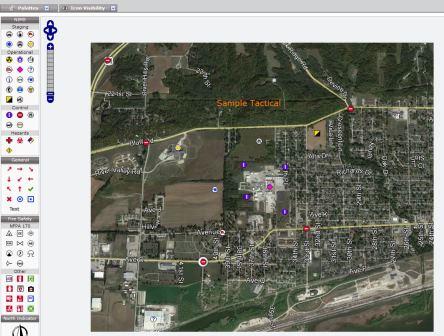
When a school or other facility is first mapped, there are two options: 1) Price would be $0.16 per sq ft to have a team come to the site, take all photos, add floorplans, personnel, etc. This would be a package that would be rollout ready, with no work provided from the school or district (example: 100,000 sq ft school would be $16,000 to rollout). Once information is added, WASPC will conduct a Pre-Plan Tactical meeting with local responders to determine a pre-plan. Any training would be provided when requested at no additional cost. 2) Price would be a flat rate determined by the sq ft of the building (100,000 sq ft or less is $1,000, 100,001 sq ft or more is $1,500). The fee covers the following: All training needed at the school or district level, Administrative oversite by the School Safety Support program at WASPC, and the Pre-Plan Tactical performed by WASPC with all Local Responders. The school or district would be trained in the following: how to add and update information, trained on the Easy Alert Program, and how to perform the Administration Functions of the Rapid Responder System. Once the training is complete, school and/or district personnel would be responsible for adding all the data and information to the Rapid Responder Program. Once information is added, WASPC will conduct a Pre-Plan Tactical meeting with local responders to determine a pre-plan. All training would be provided when requested at no additional cost. A critical part of each mapping process is called the Pre-Plan Tactical Meeting. WASPC facilitates a meeting between law enforcement, the fire department, and school or other site officials. A customized tactical response plan is developed to respond to a worst case active shooter incident at the site. This plan is represented with common language and icons on a site aerial and loaded into Rapid Responder for access by site and responding agencies. WASPC trains site and responder users across the state in how to use the system to access the information. (This is called Navigation Training.) Site users are trained to keep the information up to date, and how to use the system to document training, drills, chemical inventories, and revised emergency procedures (Administrative Training). WASPC manages access to the site, and provides “customer support.” Click here for training opportunities.
Emergency Uses of the System
Daily Uses of the System
Current Initiatives
WASPC and its contractor agency, Venuetize LLC, are currently reaching out to the following types of facilities for possible inclusion in the system:
Rapid Responder Easy Alert Additional Information
|
News Releases
2024 Post-Session StatementStatement on I-2113
Statement on HB 1445
2024 Pre-Session Statement
2022 Crime in Washington
WASPC Elects New Leaders
Post Session Statement - 2023
WASPC Statement on Blake SB 5336
WASPC Statement on House Passage SB 5352 - Pursuits Legislation
WASPC News Release Archive
Executive Director Newsletter
|
|
4/18/2024- Executive Director Update 3/22/2024 - Executive Director Update 2/21/2024 - Executive Director Update 2/1/2024 - Executive Director Update 1/26/2024 - Executive Director Update Executive Director Newsletters Archive For Mr. Strachan's Bio, click photo |